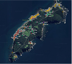
No, it’s a drone! Two pilots operating two surveillance drones in a systematic grid pattern covered the full extent of Motuora island to identify and map weed sites. We expect to save many hours of on-foot searching. Volunteers can use an app to navigate direct to the waypointed weed site and treat weeds as necessary.
With support from the Department of Conservation, and approval to fly a drone that day, Motuora Restoration Society commissioned Island Solutions geoff@islandsolutions.com to carry out the work to document the distribution and relative abundance of invasive weed species. The image below forms part of the interim report we received from work done in June. A second day is planned for September–October 2026. This timing is selected to coincide with more favourable phenological conditions.
Key: Blue - Mothplant Yellow - Boneseed Green - Woolley Nightshade Red - Gorse Purple – Pampas